
PAARL: PAARL & BRETAGNE ROCK
.
.
July 2020
Paarl -meaning pearl in Dutch – is famous for its wine, and the granite boulders on the mountain bordering the town. When wet the colour of the large boulders are said to resemble that of a pearl, hence the name Paarl Rock. It forms part of the Cape fold mountains and is a national heritage site.
Follow the dirt road turn off for roughly 6km, wind your way up the mountain, and you will come to the Meulwater braai and picnic area. Here you can safely park your car under the Italian Pine tree’s and make use of the sites clean ablutions and braai (bbq) facilities.
The hike to Paarl and Bretagne Rock is fairly short, roughly 4km there and back. As you make your way up the 1st slab of granite rock you will come across an interesting boulder near the top. Covered in craters and holes, caused by wind and water erosion, it makes for an excellent yet difficult rock climbing route. As you move around the boulder you will come across a summit beacon, as well as an old cannon. The cannon was used by the early settlers as a signal system, to warn farmers in the area of ships (friend or foe) in the Table Bay harbour. To the right, in the distance, you will see a second taller rock formation, Bretagne Rock.
The hike up Bretagne Rock involves navigating a long, steep section of granite, where you will need to make use of a chain handrail. It does look intimidating from the bottom, but its not as bad as it appears. Hold on tight and go slowly and you will be fine.
This is the most challenging part of the hike. When wet the granite is extremely slippery, so the correct footwear is essential. There are also sections where you will be on all fours, as you scramble up or down short slippery sections. Its not a very technical hike but its not a simple stroll up either, you need to have some flexibility and those with mobility issues will really struggle.
The route was fairly well marked, but we did have to scramble up some rocky surfaces to get to Bretagne Rock. So we may have somehow lost the correct path. It was easy to find our way back though, you can’t really get lost on top of a boulder! We all felt safe in the reserve and facilities are great. Go enjoy the hike and have a braai afterwards!
Please note that this is our interpretation of the hike and is not meant to be used for navigation purposes. Hiking can involve dangerous elements, and remember that the weather on top of a mountain is always different to that at the base. Remain aware of your surroundings at all times, wear the appropriate clothing and footwear, don’t litter and stick to the foot paths. Do not light a fire no matter what.
NEED TO KNOW:
- DURATION: 1.5 – 3.5 hours depending on your fitness levels.
- DISTANCE: ±4 km
- EFFORT LEVEL: 3/10
- TECHNICAL DIFFICULTY: 3/10
- REQUIREMENTS: Comfortable shoes with adequate grip, water bottle, snacks, warm top.
- ENTRY FEE: On weekends its R50 per vehicle, and R17 per passenger. Free during the week.
- DISTANCE FROM CAPE TOWN: ±70 km
- AMENITIES: Well maintained toilets
- SAFETY: 6.5/10 (slippery rocks). Always monitor your surroundings.
- ROUTE MARKINGS: 7/10
- SCENERY: 7/10
Send us a message and together we will design your day of fun and adventure!
PAARL:
PAARL & BRETAGNE ROCK




July 2020
Paarl -meaning pearl in Dutch – is famous for its wine, and the granite boulders on the mountain bordering the town. When wet the colour of the large boulders are said to resemble that of a pearl, hence the name Paarl Rock. It forms part of the Cape fold mountains and is a national heritage site.
Follow the dirt road turn off for roughly 6km, wind your way up the mountain, and you will come to the Meulwater braai and picnic area. Here you can safely park your car under the Italian Pine tree’s and make use of the sites clean ablutions and braai (bbq) facilities.
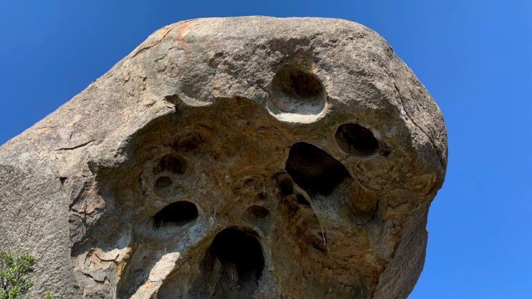
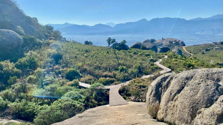
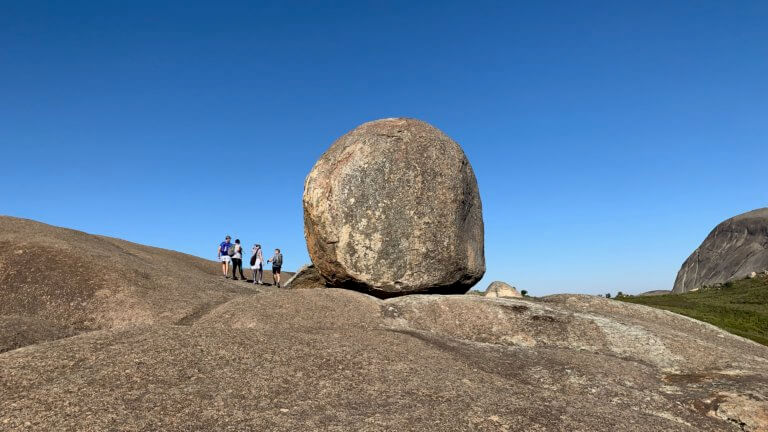
The hike to Paarl and Bretagne Rock is fairly short, roughly 4km there and back. As you make your way up the 1st slab of granite rock you will come across an interesting boulder near the top. Covered in craters and holes, caused by wind and water erosion, it makes for an excellent yet difficult rock climbing route. As you move around the boulder you will come across a summit beacon, as well as an old cannon. The cannon was used by the early settlers as a signal system, to warn farmers in the area of ships (friend or foe) in the Table Bay harbour. To the right, in the distance, you will see a second taller rock formation, Bretagne Rock.
The hike up Bretagne Rock involves navigating a long, steep section of granite, where you will need to make use of a chain handrail. It does look intimidating from the bottom, but its not as bad as it appears. Hold on tight and go slowly and you will be fine.
This is the most challenging part of the hike. When wet the granite is extremely slippery, so the correct footwear is essential. There are also sections where you will be on all fours, as you scramble up or down short slippery sections. Its not a very technical hike but its not a simple stroll up either, you need to have some flexibility and those with mobility issues will really struggle.
The route was fairly well marked, but we did have to scramble up some rocky surfaces to get to Bretagne Rock. So we may have somehow lost the correct path. It was easy to find our way back though, you can’t really get lost on top of a boulder! We all felt safe in the reserve and facilities are great. Go enjoy the hike and have a braai afterwards!
NEED TO KNOW:
- DURATION: 1.5 – 3.5 hours depending on your fitness levels.
- DISTANCE: ±4 km
- EFFORT LEVEL: 3/10
- TECHNICAL DIFFICULTY: 3/10
- REQUIREMENTS: Comfortable shoes with adequate grip, water bottle, snacks, warm top.
- ENTRY FEE: On weekends its R50 per vehicle, and R17 per passenger. Free during the week.
- DISTANCE FROM CAPE TOWN: ±70 km
- AMENITIES: Well maintained toilets
- SAFETY: 6.5/10 (slippery rocks). Always monitor your surroundings.
- ROUTE MARKINGS: 7/10
- SCENERY: 7/10
*Please note that this is our interpretation of the hike and is not meant to be used for navigation purposes. Hiking can involve dangerous elements, and remember that the weather on top of a mountain is always different to that at the base. Remain aware of your surroundings at all times, wear the appropriate clothing and footwear, don’t litter and stick to the foot paths. Do not light a fire no matter what.
Send us a message and together we will design your day of fun and adventure!
PAARL:
PAARL ROCK
July 2020
Paarl -meaning pearl in Dutch – is famous for its wine, and the granite boulders on the mountain bordering the town. When wet the colour of the large boulders are said to resemble that of a pearl, hence the name Paarl Rock. It forms part of the Cape fold mountains and is a national heritage site.
Follow the dirt road turn off for roughly 6km, wind your way up the mountain, and you will come to the Meulwater braai and picnic area. Here you can safely park your car under the Italian Pine tree’s and make use of the sites clean ablutions and braai (bbq) facilities.
The hike to Paarl and Bretagne Rock is fairly short, roughly 4km there and back. As you make your way up the 1st slab of granite rock you will come across an interesting boulder near the top. Covered in craters and holes, caused by wind and water erosion, it makes for an excellent yet difficult rock climbing route. As you move around the boulder you will come across a summit beacon, as well as an old cannon. The cannon was used by the early settlers as a signal system, to warn farmers in the area of ships (friend or foe) in the Table Bay harbour. To the right, in the distance, you will see a second taller rock formation, Bretagne Rock.
The hike up Bretagne Rock involves navigating a long, steep section of granite, where you will need to make use of a chain handrail. It does look intimidating from the bottom, but its not as bad as it appears. Hold on tight and go slowly and you will be fine.
This is the most challenging part of the hike. When wet the granite is extremely slippery, so the correct footwear is essential. There are also sections where you will be on all fours, as you scramble up or down short slippery sections. Its not a very technical hike but its not a simple stroll up either, you need to have some flexibility and those with mobility issues will really struggle.
The route was fairly well marked, but we did have to scramble up some rocky surfaces to get to Bretagne Rock. So we may have somehow lost the correct path. It was easy to find our way back though, you can’t really get lost on top of a boulder! We all felt safe in the reserve and facilities are great. Go enjoy the hike and have a braai afterwards!
NEED TO KNOW:
- DURATION: 1.5 – 3.5 hours depending on your fitness levels.
- DISTANCE: ±4 km
- EFFORT LEVEL: 3/10
- TECHNICAL DIFFICULTY: 3/10
- REQUIREMENTS: Comfortable shoes with adequate grip, water bottle, snacks, warm top.
- ENTRY FEE: On weekends its R50 per vehicle, and R17 per passenger. Free during the week.
- DISTANCE FROM CAPE TOWN: ±70 km
- AMENITIES: Well maintained toilets
- SAFETY: 6.5/10 (slippery rocks). Always monitor your surroundings.
- ROUTE MARKINGS: 7/10
- SCENERY: 7/10
*Please note that this is our interpretation of the hike and is not meant to be used for navigation purposes. Hiking can involve dangerous elements, and remember that the weather on top of a mountain is always different to that at the base. Remain aware of your surroundings at all times, wear the appropriate clothing and footwear, don’t litter and stick to the foot paths. Do not light a fire no matter what.
Send us a message and together we will design your day of fun and adventure!