
TABLE MOUNTAIN: PIPE TRACK
.
.
November 2020
Pipe Track is a great way to sample what Table Mountain has to offer without having to hike to the summit. The route gets its name from the water pipe that was laid in the 1800’s and used to transport water from the back of the mountain to the Molteno Reservoir, and then supply the city. The pipe would need to be serviced and therefore a walk way was built to give the maintenance men access.
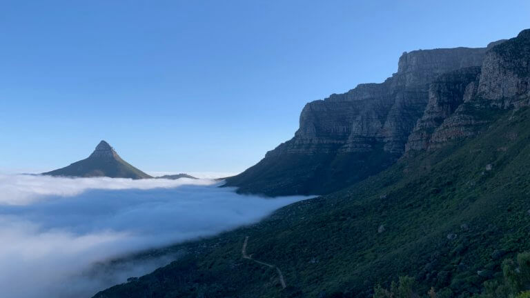
It is an extremely popular route, with spectacular views of Camps Bay, the 12 Apostles as well as Lions Head. Dog walkers, runners and hikers all share the path…as do birds, small Agama lizards (the size of your hand), as well as the occasional Caracal! But you need not worry about the Caracal, sightings are extremely rare and the animal is generally very skittish and disappears very quickly.
There are 2 starting points to this walk. The first one being at the corner of Kloof Nek and Tafelberg Road. There is a parking lot immediately to your left when you turn off Kloof Nek onto Tafelberg, which has clean and well maintained bathrooms. The trail starts on the grass bank, across the road and to opposite the bathrooms. There is a short little climb a few hundred meters in, but after that its pretty much a flat contour path. The route is as long was you want to make it, but if you continue to follow it you will eventually end up at the top of Table Mountain via Corridor Ravine after roughly 7km. You will pass a pump house, caves with views of Lions Head, small waterfalls and numerous trails leading up the mountain.
The other option is to park at Teresa Avenue in Camps Bay, which cuts out a few km’s and gets you closer to the waterfall and the start of Corridor Ravine. Please note that this is a residential area, so keep the noise levels as low as possible and do not park in residents drive ways, you will get towed.
The best time for this walk is in the morning, as the mountain shades you from the sun. It is fully exposed in the afternoon, which can be rather unpleasant when the temperature peaks above 30°c. Its a very popular route for good reason, not too difficult, beautiful views and relatively safe.
Please note that this is our interpretation of the hike and is not meant to be used for navigation purposes. Hiking can involve dangerous elements, and remember that the weather on top of a mountain is always different to that at the base. Remain aware of your surroundings at all times, wear the appropriate clothing and footwear, don’t litter and stick to the foot paths. Do not light a fire no matter what.
NEED TO KNOW:
- DURATION: 1 – 4 hours depending on how far you walk. Trail ends after ±7km at the top of Corridor ravine.
- EFFORT LEVEL: 3/10
- TECHNICAL DIFFICULTY: 2/10
- REQUIREMENTS: Comfortable shoes, water bottle, snacks, warm top.
- ENTRY FEE: No entry fee.
- AMENITIES: Toilets at Kloof Nek parking, nothing at Teresa Avenue.
- SAFETY: 8/10 Always be aware of your surroundings.
- ACCESSIBILITY: This is an easy walk that most people will be able to manage including small kids
- SCENERY: 10/10
Send us a message and together we will design your day of fun and adventure!
TABLE MOUNTAIN:
PIPE TRACK




November 2020
Pipe Track is a great way to sample what Table Mountain has to offer without having to hike to the summit. The route gets its name from the water pipe that was laid in the 1800’s and used to transport water from the back of the mountain to the Molteno Reservoir, and then supply the city.
The pipe would need to be serviced and therefore a walk way was built to give the maintenance men access.
It is an extremely popular route, with spectacular views of Camps Bay, the 12 Apostles as well as Lions Head. Dog walkers, runners and hikers all share the path…as do birds, small Agama lizards (the size of your hand), as well as the occasional Caracal! But you need not worry about the Caracal, sightings are extremely rare and the animal is generally very skittish and disappears very quickly.
There are 2 starting points to this walk. The first one being at the corner of Kloof Nek and Tafelberg Road. There is a parking lot immediately to your left when you turn off Kloof Nek onto Tafelberg, which has clean and well maintained bathrooms. The trail starts on the grass bank, across the road and to opposite the bathrooms. There is a short little climb a few hundred meters in, but after that its pretty much a flat contour path. The route is as long was you want to make it, but if you continue to follow it you will eventually end up at the top of Table Mountain via Corridor Ravine after roughly 7km. You will pass a pump house, caves with views of Lions Head, small waterfalls and numerous trails leading up the mountain.
The other option is to park at Teresa Avenue in Camps Bay, which cuts out a few km’s and gets you closer to the waterfall and the start of Corridor Ravine. Please note that this is a residential area, so keep the noise levels as low as possible and do not park in residents drive ways, you will get towed.
The best time for this walk is in the morning, as the mountain shades you from the sun. It is fully exposed in the afternoon, which can be rather unpleasant when the temperature peaks above 30°c. Its a very popular route for good reason, not too difficult, beautiful views and relatively safe.
NEED TO KNOW:
- DURATION: 1 – 4 hours depending on how far you walk. Trail ends after ±7km at the top of Corridor Ravine.
- EFFORT LEVEL: 3/10
- TECHNICAL DIFFICULTY: 2/10
- REQUIREMENTS: Comfortable shoes, water bottle, snacks, warm top.
- ENTRY FEE: No entry fee.
- AMENITIES: Toilets at Kloof Nek parking, nothing at Teresa Avenue.
- SAFETY: 8/10 Always be aware of your surroundings.
- ACCESSIBILITY: This is an easy walk that most people will be able to manage including small kids
- SCENERY: 10/10
Please note that hiking can involve dangerous elements, and remember that the weather on top of a mountain is always different to that at the base. Remain aware of your surroundings at all times, wear the appropriate clothing and footwear, don’t litter and stick to the foot paths. Do not light a fire no matter what.
Send us a message and together we will design your day of fun and adventure!
TABLE MOUNTAIN:
PIPE TRACK
November 2020
Pipe Track is a great way to sample what Table Mountain has to offer without having to hike to the summit. The route gets its name from the water pipe that was laid in the 1800’s and used to transport water from the back of the mountain to the Molteno Reservoir, and then supply the city.
The pipe would need to be serviced and therefore a walk way was built to give the maintenance men access.
It is an extremely popular route, with spectacular views of Camps Bay, the 12 Apostles as well as Lions Head. Dog walkers, runners and hikers all share the path…as do birds, small Agama lizards (the size of your hand), as well as the occasional Caracal! But you need not worry about the Caracal, sightings are extremely rare and the animal is generally very skittish and disappears very quickly.
There are 2 starting points to this walk. The first one being at the corner of Kloof Nek and Tafelberg Road. There is a parking lot immediately to your left when you turn off Kloof Nek onto Tafelberg, which has clean and well maintained bathrooms. The trail starts on the grass bank, across the road and to opposite the bathrooms. There is a short little climb a few hundred meters in, but after that its pretty much a flat contour path. The route is as long was you want to make it, but if you continue to follow it you will eventually end up at the top of Table Mountain via Corridor Ravine after roughly 7km. You will pass a pump house, caves with views of Lions Head, small waterfalls and numerous trails leading up the mountain.
The other option is to park at Teresa Avenue in Camps Bay, which cuts out a few km’s and gets you closer to the waterfall and the start of Corridor Ravine. Please note that this is a residential area, so keep the noise levels as low as possible and do not park in residents drive ways, you will get towed.
The best time for this walk is in the morning, as the mountain shades you from the sun. It is fully exposed in the afternoon, which can be rather unpleasant when the temperature peaks above 30°c. Its a very popular route for good reason, not too difficult, beautiful views and relatively safe.
NEED TO KNOW:
- DURATION: 1 – 4 hours depending on how far you walk. Trail ends after ±7km at the top of Corridor Ravine.
- EFFORT LEVEL: 3/10
- TECHNICAL DIFFICULTY: 2/10
- REQUIREMENTS: Comfortable shoes, water bottle, snacks, warm top.
- ENTRY FEE: No entry fee.
- AMENITIES: Toilets at Kloof Nek parking, nothing at Teresa Avenue.
- SAFETY: 8/10 Always be aware of your surroundings.
- ACCESSIBILITY: This is an easy walk that most people will be able to manage including small kids
- SCENERY: 10/10
Please note that hiking can involve dangerous elements, and remember that the weather on top of a mountain is always different to that at the base. Remain aware of your surroundings at all times, wear the appropriate clothing and footwear, don’t litter and stick to the foot paths. Do not light a fire no matter what.
Send us a message and together we will design your day of fun and adventure!